


Table of Contents Show
If you’ve ever ventured to Maine or Michigan for the summer, you might have considered crossing the border and spending a day or two in Canada.
Or, if you’ve planned a road trip to Alaska, your route will take you through the western provinces of our northern neighbor.
So have you ever wondered what are Canadian provinces? Canada has no states, so how does the country divide its land? Let’s look closer and learn about its provinces and territories!
How Big Is Canada?
Canada is the second-largest country in the world, extending from the Pacific to the Atlantic to the Arctic Ocean.
It has the world’s longest coastline. The total area is almost 10 million square kilometers. Roughly 39 million people live in Canada.
Does Canada Have States?
Unlike the United States, Canada doesn’t have states. Instead, it divides its land into provinces and territories. The provinces have more sovereignty and power than the territories.
They’re also more heavily populated. Additionally, these regions are much bigger than our American states.
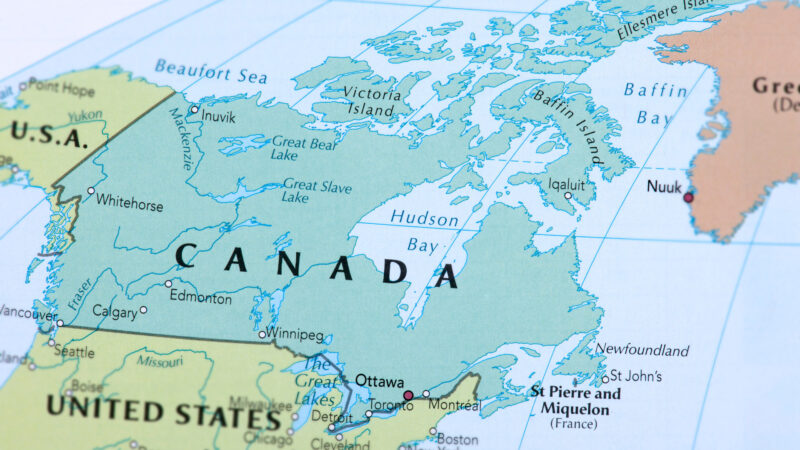
What Are Canadian Provinces?
Canada has 10 provinces. The farthest west is British Columbia, and the farthest east is Newfoundland and Labrador.
These provinces operate similarly to states in America. They have co-sovereign governments with responsibilities divided between the federal and the provincial governments.
1. British Columbia
British Columbia’s capital is Victoria, but its largest city is Vancouver. Over 5 million people call this Canadian province home. It’s the third-largest province behind Quebec and Ontario in terms of area.
Many Americans visit British Columbia, especially on drives to Alaska. This Canadian province borders Alberta, the territories of Yukon and the Northwest Territories, the states of Washington, Idaho, and Montana to the south, and Alaska to the northwest.
Forestry, mining, filmmaking and video production, tourism, real estate, and construction are all critical sectors in the British Columbia economy. It’s also home to the Port of Vancouver, the largest port in Canada.
Seven of Canada’s national parks also lie in British Columbia: Glacier National Park, Gulf Islands National Park Reserve, Gwaii Haanas National Park Reserve and Haida Heritage Site, Kootenay National Park, Mount Revelstoke National Park, Pacific Rim National Park Reserve, and Yoho National Park.
2. Alberta
Going from west to east, Alberta is the next Canadian province. Its capital is Edmonton, but its largest city is Calgary. About 4.6 million people live here. Interestingly, Alberta is only one of two landlocked Canadian provinces.
British Columbia, Saskatchewan, the Northwest Territories, and the state of Montana border the province of Alberta. The western part of the province is home to the Rocky Mountains, while the eastern part of the province is home to the Great Plains.
Important industries in Alberta include hydrocarbons, petrochemical industries, livestock, agriculture, and oil and gas. In fact, this province produces 70% of Canada’s oil and natural gas.
In addition to its natural resources, Alberta is also known for its beauty. It has six UNESCO-designated World Heritage Sites in this Canadian province.
Alberta also has the Canadian Rocky Mountain Parks, Dinosaur Provincial Park, Waterton-Glacier International Peace Park, Wood Buffalo National Park, Writing-on-Stone Provincial Park, Banff National Park, Elk Island National Park, Jasper National Park, and Waterton Lakes National Park.
3. Saskatchewan
The third of the westernmost Canadian provinces is Saskatchewan. Its capital is Regina, but its largest city is Saskatoon. About 1.2 million people live in this province. It’s the second of Canada’s landlocked provinces. However, 10% of Saskatchewan’s total area is fresh water.
Alberta, the Northwest Territories, Manitoba, Nunavut, and the states of Montana and North Dakota border Saskatchewan. This Canadian province’s two main natural regions are the Boreal Forest in the north and the Prairies in the south.
Additionally, the Lake Athabasca Sand Dunes, the northernmost active sand dunes in the world, lie within Saskatchewan. You’ll also find two of Canada’s national parks: Prince Albert National Park and Grasslands National Park.
Agriculture, mining, and forestry are three of the top industries here. Saskatchewan is the world’s largest exporter of mustard seed and grows a large portion of Canada’s grain.
4. Manitoba
The capital and largest city of Manitoba is Winnipeg. Approximately 1.4 million people call this Canadian province home. Manitoba is one of the most diverse provinces with arctic tundra, dense boreal forest, freshwater lakes, and prairie grasslands. More than 110,000 lakes cover more than 15% of its surface area.
The Hudson Bay, Ontario, Saskatchewan, Nunavut, and the states of North Dakota and Minnesota border the province of Manitoba.
Lake Winnipeg, the tenth-largest freshwater lake in the world, Lake Manitoba, and Lake Winnipegosis sit in the southern half of the province. Manitoba is home to Riding Mountain National Park and Wapusk National Park, and numerous historic sites.
Agriculture, tourism, electricity, oil, mining, and forestry are major industries. Manitoba is Canada’s largest producer of sunflower seed and dry beans and one of the leading producers of potatoes.
Western Canada’s largest winter festival is the Festival du Voyageur, a 10-day event held in Winnipeg’s French Quarter.
5. Ontario
The second-largest Canadian province is Ontario, located between Manitoba and Quebec. Its capital and largest city is Toronto. Ottawa, Canada’s national capital, is also located here. It’s by far the most populous province, with over 15 million residents.
Manitoba, Hudson Bay, James Bay, Quebec, and the states of Minnesota, Michigan, Ohio, Pennsylvania, and New York border Ontario. Point Pelee National Park is the southernmost part of Canada’s mainland and extends into Lake Erie.
Seven of Canada’s national parks and protected areas are also here: Bruce Peninsula National Park, Fathom Five National Marine Park, Georgian Islands National Park, Point Pelee National Park, Pukaskwa National Park, Thousand Islands National Park, and Lake Superior National Marine Conservation Area.
Agriculture, forestry, and mining are all essential economic industries. But Ontario is Canada’s leading manufacturing province. Its largest trading partner is Michigan. The Great Lakes also create an excellent transportation system for container ships.
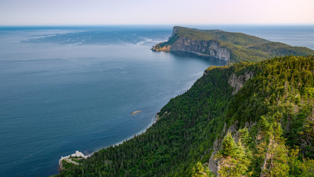
6. Quebec
The largest Canadian province in terms of area is Quebec. It’s also second in population, with over 8.7 million residents. Quebec City is the capital, while Montreal is the largest city.
This province borders Ontario, Newfoundland and Labrador, New Brunswick, and the states of Maine, New Hampshire, Vermont, and New York.
Quebec is known for its large reserve of fresh water. In fact, 12% of its surface area is water, with half a million lakes and 4,500 rivers.
In recent years, much money has poured into Quebec’s research, development, and technology sectors. This province is also known as a clean energy superpower, producing most of Canada’s hydroelectricity. Quebec is also the second biggest hydroelectricity producer in the world.
Forillon National Park, La Mauricie National Park, Mingan Archipelago National Park Reserve, and Saguenay–St. Lawrence Marine Park are all located in Quebec.
7. New Brunswick
One of the smallest provinces in Canada is New Brunswick. It’s also called one of the four Atlantic provinces. Fredericton is the capital, while Moncton is the largest city. About 825,000 people live in this province.
Quebec, Nova Scotia, the Gulf of Saint Lawrence, the Bay of Fundy, and the state of Maine border New Brunswick. It’s about 83% forested, which leads to a much lower population. They also have snowy, harsh winters.
Although New Brunswick has been one of the poorer areas of Canada, in recent years, tourism has increased with popular destinations like the Hopewell Rocks, Fundy National Park, Magnetic Hill, Kouchibouguac National Park, and Roosevelt Campobello International Park.
Keep in Mind: Did you know there is a US National Park in Canada? Click the link to see which park it is!
8. Nova Scotia
Nova Scotia, Latin for “New Scotland,” is Canada’s second-most densely populated province. With only 55,000 square kilometers, almost 970,000 people live here. It’s the second-most smallest island after Prince Edward Island.
Halifax is the capital and largest city. Nova Scotia is bordered by several bodies of water: the Bay of Fundy, the Gulf of Maine, the Atlantic Ocean, the Northumberland Strait, and the Cabot Strait.
Because of this, fishing is a huge industry, with exported value of over $14 billion. Nova Scotia is also the world’s largest exporter of Christmas trees, lobster, gypsum, and wild berries.
Cruise ships often visit the Port of Halifax, and numerous heritage sites and museums display the province’s cultural history. Nova Scotia has Kejimkujik National Park and Cape Breton Highlands National Park, and other protected areas and historic sites.
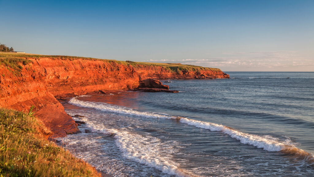
9. Prince Edward Island
The smallest Canadian province is Prince Edward Island, located in the Gulf of St. Lawrence. It’s the least populated province but most densely populated by land mass, with approximately 173,000 people living in 5,600 square kilometers. It’s the only Canadian province that is solely an island.
Beaches, sand dunes, barrier islands, and saltwater marshes define this landscape. Because of the red sandstone cliffs and sand dunes, Prince Edward Island National Park is a favorite outdoor playground for locals and visitors.
10. Newfoundland and Labrador
Finally, the tenth Canadian province is Newfoundland and Labrador. It’s also the newest addition, as it was named a province in 1949. About 532,000 people live here, and the total area is approximately 405,000 square kilometers.
The Strait of Belle Isle separates the province into two parts: Labrador, which is connected to mainland Canada, and Newfoundland, an island in the Atlantic Ocean.
Though not top destinations, Gros Morne National Park and Terra Nova National Park are protected areas. Offshore oil production, mining, and fishing are important economic industries.
Are Canadian Provinces and Territories the Same Thing?
Unlike Canadian provinces, territories aren’t co-sovereign. The federal government, Canada’s Parliament, gives these territories certain powers, whereas the provinces have constitutional powers.
Three territories include the mainland of Canada north of 60 degrees latitude, the land north and west of the Hudson Bay, and all islands north of the Canadian mainland.
What Are the Canadian Territories?
Much of Canada’s three territories are wilderness. Most Canadians live near the Canada-U.S. border and not in these far-stretching lands.
1. Yukon
Yukon is the smallest in total area, with about 482,000 square kilometers. English and French are the two official languages spoken by the 44,000 residents.
Alaska forms the western border, British Columbia forms the southern border, and the Northwest Territories forms the eastern border.
Mount Logan in Kluane National Park and Reserve in Yukon is the highest mountain in Canada at over 19,500 feet. It’s second in North America to Denali in Alaska. Ivvavik National Park and Vuntut National Park are two other northern national parks in Yukon.
2. Northwest Territories
East of Yukon is the second-largest Canadian territory: Northwest Territories. It covers over 1.3 million square kilometers.
But the population is about the same as Yukon, with approximately 45,000 residents. Nunavut, Yukon, British Columbia, Alberta, Saskatchewan, and Manitoba all border this territory.
The Northwest Territories is home to Great Bear Lake, the largest lake entirely within Canada, and Great Slave Lake, North America’s deepest body of water.
In addition, you’ll find six national parks or reserves: Thaidene Nene, Wood Buffalo, Aulavik, Nahanni, Nááts’ihch’oh, and Tuktut Nogait.
Keep in Mind: So how many national parks are in Canada? See how many there are and which are worth visiting!
Finally, Nunavut, the largest and least-populated Canadian territory, comprises much of Northern Canada and most of the Arctic Archipelago.
In fact, its 2 million square kilometers is the second-largest country subdivision in North America after Greenland. The roughly 39,000 inhabitants are mostly Inuit people.
Nunavut experiences a polar climate. Every month the average temperature remains under 50 degrees. Alert, the northernmost inhabited place in the world, has average lows of -33 degrees in the winter.
Ukkusiksalik National Park, Auyuittuq National Park, Qausuittuq National Park, Quttinirpaaq National Park, and Sirmilik National Park all lie within Nunavut.
Get to Know Our Northern Neighbor: The Canadian Provinces and Territories
We share many similarities with our northern neighbor. But we also have significant differences.
The division of the land is one of those. If you want to travel to Canada, explore its national parks, or visit its big cities, know the Canadian provinces and territories to understand better where you’re traveling.
Have you been to Canada before? If so, in which Canadian province?