


Table of Contents Show
It’s the classic American trip — traveling across the country by RV. No matter who you are or where you live, there are few better ways to see the United States than by hitting the road for a cross-country road trip. But before you pack up the RV and head out, there are some things you should know.
Let’s take a closer look at them and the best routes for your travel adventure.
Why Should You Take a Cross Country Road Trip?
There are so many great reasons to undertake this incredible journey. The better question might be, “Why not?”
So many of us end up in a bit of a bubble, only interacting with people similar to us. A cross-country road trip is a perfect way to break out of this bubble and meet new people with diverse perspectives. It’s one of the best ways to get in touch with other Americans.
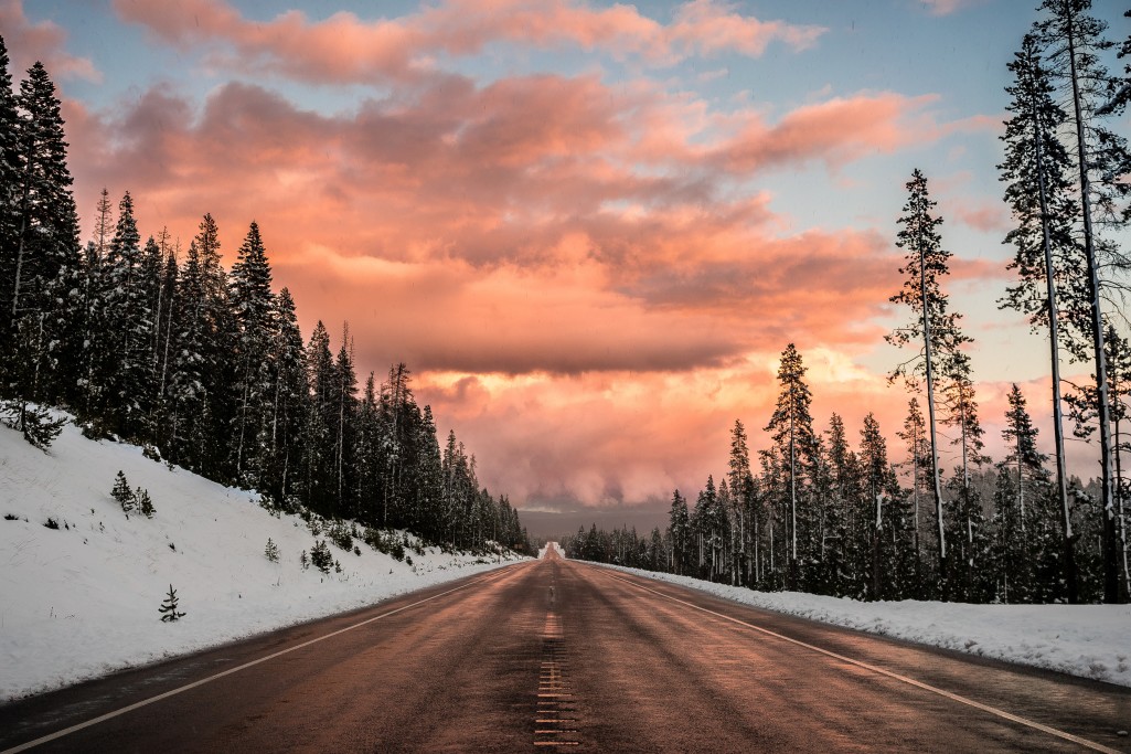
The United States is also lucky to have some of the most breathtaking and varied landscapes. From the rugged coast of New England to the Rocky Mountains, a cross-country road trip can take you through some of nature’s most remarkable environments.
And the cultures you’ll meet are just as diverse in their food, architecture, and religious and social customs. Try getting all of that from a plane trip!

Pro Tip: First time road-tripper? These 5 road trip tips are for you.
Best Cross Country Road Trips Everyone Needs to Take at Least Once
So you’ve got your budget set and the car packed, now where are you headed? Here are our picks for the best cross-country road trips that should be on every traveler’s bucket list.
Historic Route 66
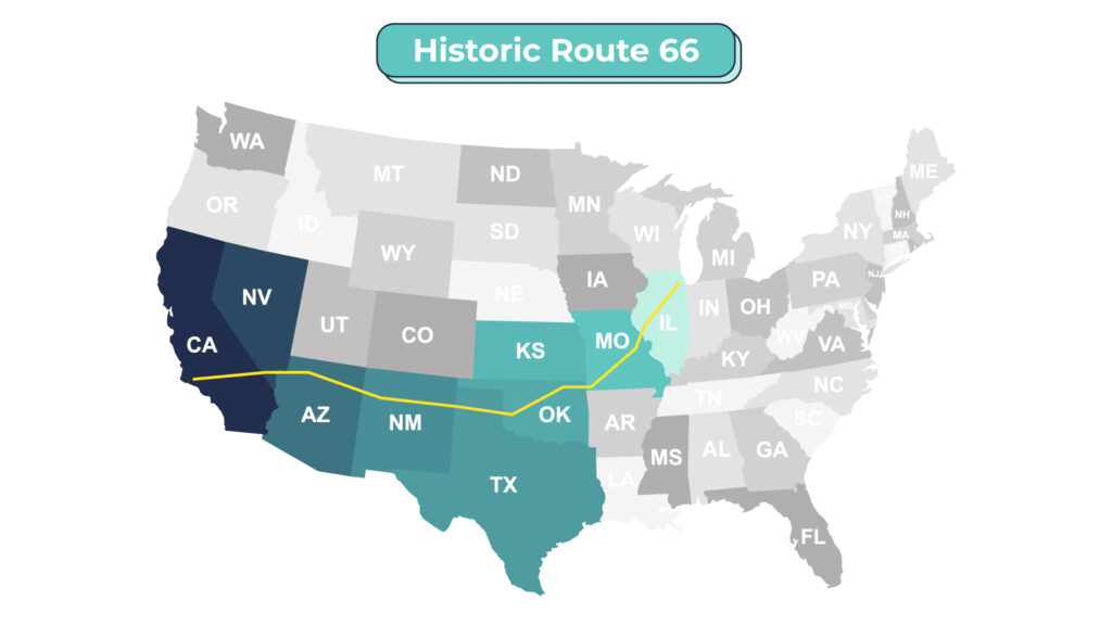
Length and the States You Will See:
2,448 miles from Illinois through Missouri, Kansas, Oklahoma, Texas, New Mexico, Arizona, and California.
Must-Visit Main Attractions:
- Chicago, Ill.
- The Mississippi River
- St. Louis, Mo.
- Red’s Giant Hamburg
(the first drive-in) - Blue Whale (Catoosa, Okla.)
- Oklahoma City, Okla.
- U-Drop Inn Cafe (Shamrock, Texas)
- Amarillo, Texas; Cadillac Ranch (Amarillo, Texas)
- Blue Hole (Santa Rosa, N.M.)
- Albuquerque, N.M.
- Santa Fe, N.M.
- Petrified Forest National Park
- Los Angeles, Calif.
About: It’s been called America’s Main Street, the Mother Road, and even Bloody 66. No matter how you refer to it, it’s clear that Route 66 is one of the most iconic cross-country road trips. First rising to prominence in the 1920s and 1930s, it was among the original highways that allowed America’s growing car-driving population to reach the west coast easily.
In its heyday in the 1950s and 1960s, it inspired countless unique tourist attractions, from gift shops to the famous motels that lined its route. It also offers some wonderful geographic diversity, from the plains of Illinois to the deserts of the southwest and the beaches of Southern California.
US-20 Route
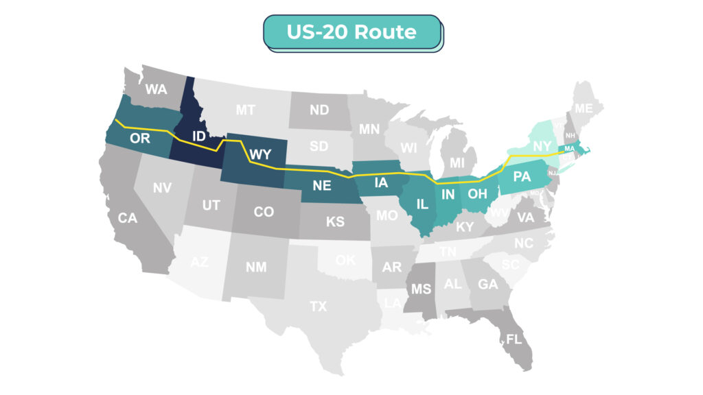
Length and the States You Will See:
3,365 miles from Massachusetts through New York, Pennsylvania, Ohio, Indiana, Illinois, Iowa, Nebraska, Wyoming, Montana, Idaho, and Oregon.
Must-Visit Main Attractions:
- Boston
- Upstate New York’s Finger Lakes
- Rock and Roll Hall of Fame (Cleveland, Ohio)
- Indiana Dunes National Park
- Chicago, Ill.
- The Mississippi River
- Yellowstone National Park
- Craters of the Moon National Monument
- Bend, Ore.
About: If you’re looking for a true road trip that takes you from sea to shining sea, hop on US-20. But make sure to gas up the car and bring some snacks. It’s the longest road in America, stretching over three thousand miles from Boston to Newport, Oregon.
Along the way, you’ll see iconic national parks like Yellowstone, major cities like Chicago and Boston, the northern plains, and countless small towns and attractions. This northern cross-country route gives road trippers a true sense of the size and diversity of the United States.

Pro Tip: Go big or go home — learn how to plan an RV trip to all 50 states.
US-50 Route
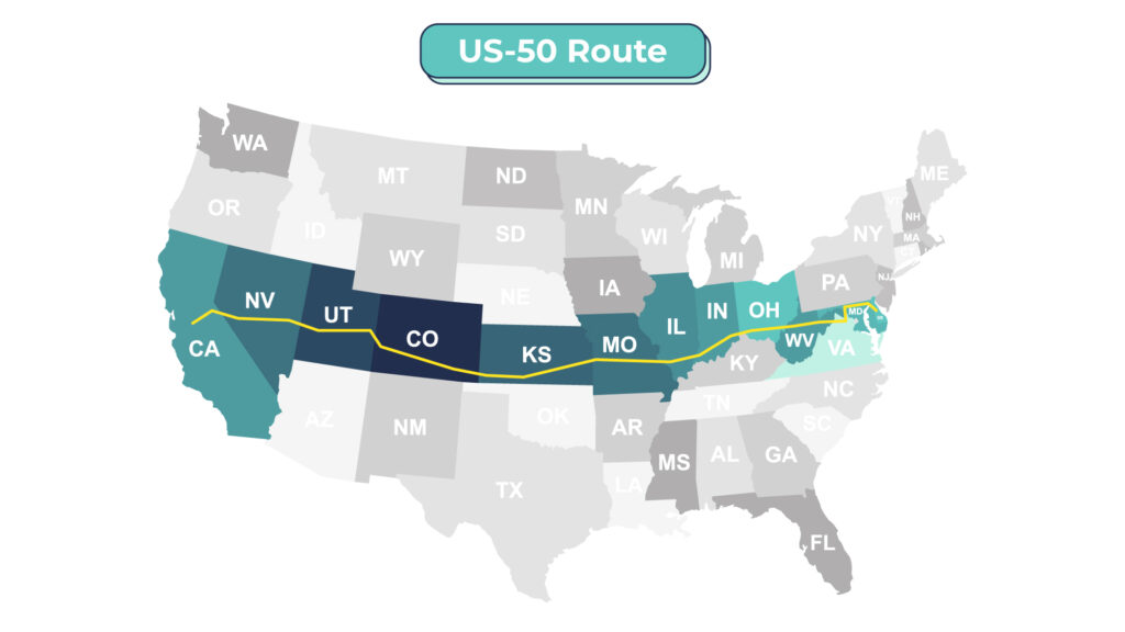
Length and the States You Will See:
3,073 miles from Maryland through DC, Virginia, West Virginia, Ohio, Indiana, Illinois, Missouri, Kansas, Colorado, Utah, Nevada, and California.
Must-Visit Main Attractions:
- Maryland beaches
- The Chesapeake Bay
- Washington, DC
- The Blue Ridge Mountains;
- Cincinnati, Ohio
- The Mississippi River
- Kansas City, Mo.
- The Rocky Mountains
- Lake Tahoe
- The Sierra Nevada Mountains
About: You may have heard US-50’s Nevada portion called the loneliest road in America. That may be true in that desolate stretch of the west. However, this more than 3,000-mile road also crosses through some big cities and countless small towns. From the beaches of Maryland, drivers can explore the history and culture of DC before an up-close look at the small towns of the midwest and great plains.
After soaring through the Rocky Mountains and the nearly uninhabited stretches of Utah and Nevada, you’ll pass gorgeous Lake Tahoe and the Sierra Nevadas before ending in the Sacramento area. If you’re looking for a quiet, solitary drive through some of America’s most vast and empty regions, this is the trip for you.
US-101 to California State Route 1
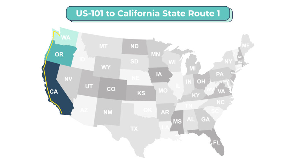
Length and the States You Will See:
1,540 miles from Washington through Oregon to California.
Must-Visit Main Attractions:
- The Olympic Mountains
- Olympic National Park
- The Columbia River
- The Oregon coast
- Redwood National Park
- The Golden Gate Bridge
- San Francisco
- California wine country
- The Pacific Coast Highway
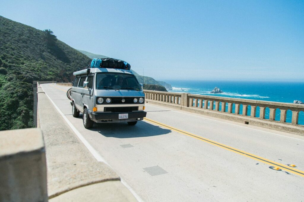
- Big Sur
- Los Angeles
About: Those looking to see the entirety of the west coast from near Canada to Southern California have several options. But, none match the scenic beauty and historic charm of US-101 and California State Route 1. From the mountains and forests of Washington state, US-101 travels along the Pacific coast through Oregon, providing some of the most scenic driving on the west coast.
In California, you’ll be able to see the state’s two biggest cities and hundreds of miles of jaw-droppingly beautiful coastline in between. The Pacific Coast Highway portion of California Route 1 is famous enough on its own. Just imagine how great driving the entire route will be!
I-95 Route
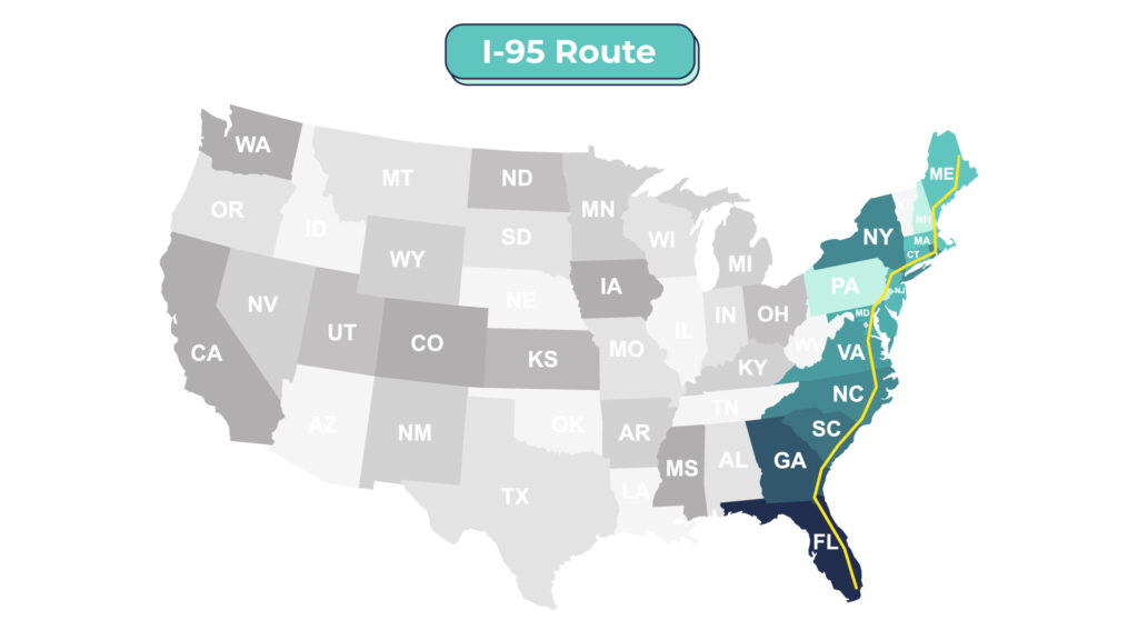
Length and the States You Will See:
1,908 miles from Maine through New Hampshire, Massachusetts, Rhode Island, Connecticut, New York, New Jersey, Pennsylvania, Delaware, Maryland, Washington, Virginia, North Carolina, South Carolina, Georgia, and Florida.
Must-Visit Main Attractions:
- U.S.-Canada Border
- Portland, Maine
- Boston, Mass.
- Providence, R.I.
- New York City, N.Y.
- Philadelphia, Pa.
- Baltimore, Md.
- Washington, DC
- Virginia’s Civil War battlefields
- Richmond, Va.
- South of the Border, S.C.
- Savannah, Ga.
- Florida’s beaches
- Miami, Fla.
About: There’s no better way to see just about every major city along the east coast than an I-95 road trip. Starting at the U.S.-Canada border in Maine, road trippers can take in the diverse attractions of a wide variety of cities, from the history of Boston, Philadelphia, and DC to the food and culture of New York and Miami.
Along the way, you’ll cross through some of the most populated regions of the United States, giving you a great perspective on how many Americans live. From the forests of Maine to skyscrapers of New York and the beaches of Miami, there’s something for everyone along this eastern odyssey.
US-2 Route
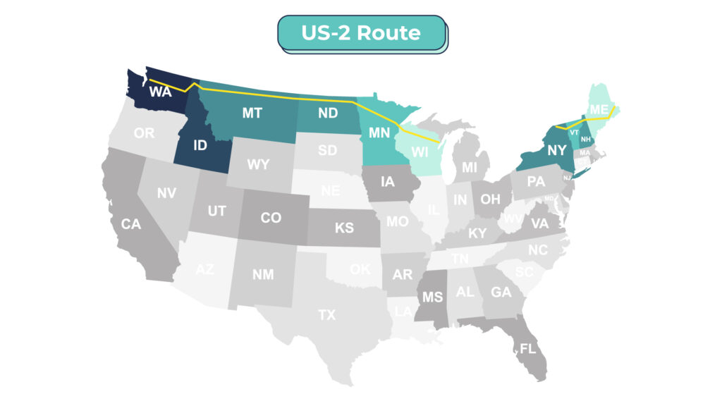
Length and the States You Will See:
1. Eastern Segment – 459 miles from Maine through New Hampshire, Vermont, and New York.
2. Western Segment – 2,115 miles from Michigan through Wisconsin, Minnesota, North Dakota, Montana, Idaho, and Washington.
Must-Visit Main Attractions:
- White Mountain National Forest
- Lake Champlain
- Montpelier, Vt.
- Michigan’s Upper Peninsula
- The Mississippi River
- The geographical center of North America (North Dakota)
- Glacier National Park
About: Want a cross-country road trip with some international flavor? Try US-2, which starts in Maine and continues through New England into Canada. It then restarts in Michigan and continues into Washington’s coast.
Starting with the unspoiled beauty of New England (and the nation’s smallest state capital in Montpelier), this most-northerly cross-country route resumes in Michigan, crossing the vast northern plains. In between, you can venture through Ontario, Canada, or stay stateside and swing south through the Rust Belt cities of Buffalo and Cleveland, and into the midwest.
How Long Do You Need for a Cross Country Road Trip?
One of the best parts of a cross-country road trip is that you can tailor your trip to the time you have available. In terms of driving time alone, it will generally take a day and a half to two days of driving (36-48 hours) to drive straight through from coast to coast (or north to south) each way, with minimal stops for food and restrooms. While this is possible with multiple people driving in shifts, it’s certainly not a very good way to experience much of the country.
Typically, a week each way would be the shortest amount of time many travelers would dedicate to a cross-country road trip. This allows some time for sightseeing along the way, without too grueling of a driving schedule.
Keep in mind that if you plan on driving your car back, you’ll need to double the time required! Still, two weeks is generally a reasonable amount of time for most people to get off work – especially when the trip of a lifetime is the reward!
How Much Does the Average Cross Country Road Trip Cost?
Naturally, the cost of everyone’s road trip will be a little different. We all have different cars, gas mileage, tastes in food and lodging, and interests in attractions. Still, it’s easy enough to calculate your cross-country road trip costs.
First, figure out the approximate number of miles you’ll be driving. Then, look up the miles per gallon of your car. Make a rough estimate of your mileage based on how much city and highway driving is part of your trip.
Divide your total miles by your miles per gallon, and then multiply this by the gas price per gallon. This will give you a good approximation of how much fuel will cost you.

Calculating Accommodations
For nightly accommodations, it’s safe to assume you’ll spend somewhere between $50 and $200 per room per night. However, it’s certainly possible to spend more if you have high-end tastes or want to stay in the most desirable areas.
It can be less if you’re up for camping or a night in a hostel. Multiply your nightly cost by the number of total nights you’ll need to find the cost of your accommodations. Food can be calculated using roughly the same formula, assuming $30 to $50 per person per day.
Add in the cost of any attractions you plan to visit or see while on the road. This can vary widely depending on your tastes and route. Are you planning on visiting an expensive amusement park or parasailing on the beach? Or are you more content with free or low-cost hikes or museums? A ballpark number here will suffice, but leave some room for unplanned excursions or splurges if you can.
Finally, it’s a good idea to pad your budget a bit for any sorts of emergencies or unexpected expenses on the road. Five percent to 10% of your total trip budget or a few hundred dollars (whichever is less) should generally cover all but the most extreme situations. If all goes well, you’ll never need to use it and still have the cash when you arrive home.
What Is the Best Month to Drive Cross Country?
Depending on your route, you can take a cross-country road trip can be taken at any time of year. However, your exact path will be important in some seasons. For example, you typically might want to avoid the Rockies in the dead of winter or the deserts of Arizona in the hottest part of summer.
Additionally, summer months or around the winter holidays may be busier in general, as families take advantage of their kids being off school. Gas prices also tend to increase in the summer, making your trip more expensive.
With all this in mind, your best bets for driving cross country will likely be in the late spring (April or May) or early fall (September or October). This will help you avoid extreme weather along your route, some of the crowds, and costs.

Is a Cross Country Road Trip Worth It?
For those looking to get to their destination as soon as possible, or those who simply can’t stand long drives in the car, a cross-country road trip may not be a good idea. However, for many, it’s the trip of a lifetime. Cross-country road trips provide an up-close-and-personal look at America and its many diverse people, sights, and landscapes.
While it may take some planning, it can be one of the most rewarding travel experiences out there. It’s one you and your fellow travelers will talk about for years to come.
Will you venture out on a cross-country road trip?


Did a cross country via US 2 in Sept.2015, leaving it in MN and skirting the Great Lakes north in Canada before returning to the US in NY. Caught the fall colors all across the US. Camped the whole way. Beautiful trip.